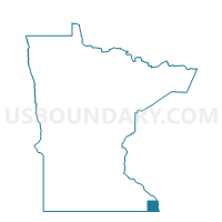
Houston Voting District, Houston County, Minnesota
About
Outline

Summary
| Unique Area Identifier | 602519 |
| Name | Houston Voting District |
| County | Houston County |
| State | Minnesota |
| Area (square miles) | 0.94 |
| Land Area (square miles) | 0.93 |
| Water Area (square miles) | 0.02 |
| % of Land Area | 98.11 |
| % of Water Area | 1.89 |
| Latitude of the Internal Point | 43.76063270 |
| Longtitude of the Internal Point | -91.57065020 |
Maps

Graphs
Select a template below for downloading or customizing gragh for Houston Voting District, Houston County, Minnesota